
Foldable
Easy to use! Easy to store. |
Accurate
Used by US Coast Guard & Navy. |
Durable
So tough you can't ruin them. |
Economical
Charts on 2 sides save you money. |
Use with GPS
Navigation made easy. |
Standard Navigation Charts
Identified by the Red Title Block. Developed in 1984, Waterproof Charts was the first company to successfully reproduce government paper charts on waterproof, tearproof, synthetic paper. Since then, our Waterproof Charts have been constantly refined and revised. New editions are easier to read, handle, fold and store. GPS waypoints are printed directly on the chart, making it easy to set up your electronics.
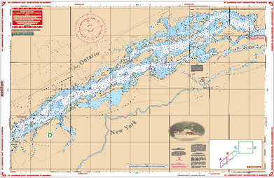
St Lawrence East/Morristown to Massena
SKU:78A
Description:
This is the perfect chart if you are cruising the St Lawrence Seaway. Area includes Morristown on side "A" and continues east to Ogdenburg, Galop, Irooquois, and Ogden Islands. Side "B" starts at Morrisburg and continues east to Ault and Croil Islands, past Massena to Barnhart Island and the Moses-Saunders Power Dam.
Many Anchorages and Marinas and speed zones are listed. See adjoining chart # 78 if you want full coverage from Wolfe Island to Morristown.
25" x 38"
$26.95
email boatparts@boatsunlimitedny.com or Call 1866-868-7151
Buy Now at our Online Store
Call BU at 1-866-868-7151 or Email boatparts@boatsunlimitedny.com for
more information on Chart Kits prices and availability.
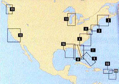
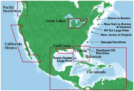
Great Lakes Region
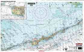
Lake Ontario Thousand Island Area Charts
76 .LAKE ONTARIO - NORTHEAST LAKE ONTARIO - Entire lake coverage from Kingston to Hamilton on one side with 35 GPS AND LORAN WAYPOINTS indexed and indicated on the chart. Detailed coverage of the Northeast section of the lake from Stony Point west to False Ducks Islands and north to Kingston and east to Clayton. Covers the Cape Vincent Area and the popular Sacketts Harbor and Henderson Harbor Area. 16 GPS and LORAN WAYPOINTS are printed directly on the chart. Information from 2 NOAA Charts; 14802 & 14800
Price: $26.95 WPC76
78 .THE THOUSAND ISLANDS - Combination of several government charts. From Wolfe Island, covers the Clayton and Gananoque area east to Wellesley Island, Hill Island and Alexandria Bay. Details of Clayton, Alexandria Bay. The reverse side cover the seaway from Dingman Point northeast to Brockville and Morristown, NY. All you need for this popular summer area. Color Key and Large Print Place Names make this chart exceptionally easy to use. Information from 4 NOAA Charts; 14767, 14766, 14765 and 14764. GPS Datum
Price:$26.95 WPC78
140..CLAYTON AND ALEXANDRIA BAY - Exceptionally detailed coverage of the heart of this very popular vacation and boating area. A combination of 3 government charts on one sheet for a close up view. Brightly colored, the shallows and marsh areas are easy to spot. GPS waypoints added. The west side covers Clayton area with coverage from Wolfe Island Cut east to Thousand Island Park and Fishers Landing including all of Grindstone Island. A must-have for the boat and home or office, both sides are suitable for framing. The east side covers the Alexandria Bay area with Wellesley Island and the Canadian Middle Channel east to the Summerland Island Group. Information from 3 NOAA charts; 14772, 14773 and 14774. GPS datum
Price: $26.95 WPC140
Buy Now at our Online Store
Inshore Fishing 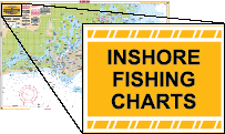
These charts have all of the great quality features you've come to expect from Waterproof Charts! They cover the inshore fishing areas in complete detail, and pinpoint dozens of fishing areas and the fish caught in each area. They also include a detailed marine facilities guide, giving locations of boat ramps, waterfront restaurants, bait and tackle locations, and more.
Lake Fishing Charts
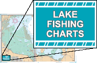
These NEW Lake Fishing Charts include the most up-to-date information available from NOAA Resources, local captains and tackle stores. The most popular fishing areas are highlighted, the species caught in that area are noted and the pre-plotted GPS coordinate is given. Most popular Marine locations are listed as well.
Call BU at 1-866-868-7151 or Email boatparts@boatsunlimitedny.com for
more information on Chart Kits prices and availability.
 Back Back
|